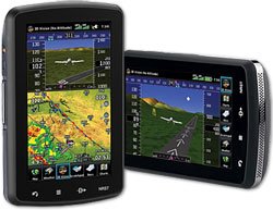
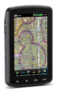
جی پی اس هوا نوردی گارمین Garmin GPS AERA 795
جی پی اس هوانوردی گارمین ساخت امریکا دارای تمام اطلاعات فروذگاههای جهان - فرکانسها و ایر اسپیس ها دریافت مستقیم سیگنال از ماهواره ها مناسب برای دانشجویان خلبانی و  دارندگان  هواپیماهای شخصی باتری دهی بیش از 5 ساعت در یک پرواز نقشه ایستگاههای ناوبری از قبیل VOR  و سایر اعلاعات مسیر به اضافه    اینسترومنتهای مجازی      مقداری کارکرده  - سالم و در حد نو - بدون جعبه   لوازم اضافی : کیف پارچه ای JEPESEN  و ساپورت زانو برای بستن روی زانو هنگام پرواز   خریداری شده مستقیما از گارمن امریکا  دست اول
کد محصول: Garmin GPS AERA 795
دسته بندی: شبیه ساز پرواز و تجهیزات مربوطه ,
مقایسه شود
98,000,000تومان
æra™ 795 Aviation Portable GPS

FEATURES

  • 7" diagonal, touchscreen aviation portable GPS (not designed for automotive)
  • 3D navigation, advanced electronic flight bag capabilities
  • Virtual 3D behind-the-aircraft perspective of surrounding terrain derived from GPS and the on board terrain database
  • High-definition, sunlight-readable display
  • Works in both portrait and landscape mode
  • Optimized design to fit on the yoke or use as a knee-mounted device
  • 4 touch keys on bezel: back, menu, direct-to and nearest for quick navigation
  • All other functions are accessed through intuitive on screen icons with labels
  • Quickly pan across the map screen & pinch to zoom
  • Fulfills the role of either a Class I or Class II electronic flight bag
  • Initial georeferenced VFR sectional & IRF enroute charts come preloaded
  • IFR mode displays victor airways, jet routes, minimum enroute altitudes and leg distance
  • FliteCharts provide approach charts and airport diagrams for the US, while pilots who prefer Jeppesen can use optional ChartView services
  • Document viewer
  • Scratch Pad feature
  • Checklist Viewer - allows for customized and interactive electronic checklists
  • Enhanced situation awareness with 3D mode, and top-down view of your entire route
  • SafeTaxi provides detailed taxiway diagrams and position information for over 1000 US airports
  • Private airport and heliport database expands emergency "nearest" options
  • FBO, ground transportation, lodging and other facility information for most US airports are available through preloaded AOPA airport directory data
  • International pilots may choose to global AC-U-KWIK airport directory data instead
  • 2 serial ports
  • Allows for simultaneous connectivity with other hardware
  • Optional Garmin GTX 330 Mode S Transponder interface to access TIS alerts, where available, on the device
  • Optional Garmin SL30/40 radio is also compatible
  • Includes SD card slot for easy updates and expansions
  • Features include: moving map, panel page, HSI (GPS-based), IFR map mode, TIS alerts compatible, Audible Terrain alerts, standard Terrain resolution, Smart Airspace feature, Automatic logbook, and Separate serial and USB interfaces
SPECIFICATIONS
PHYSICAL & PERFORMANCE
Dimensions: 5.1"W x 8.0"H x 1.5"D
Display Size: 3.6"W x 6.0"H, 7.0" Diagonal, 480 x 800 pixel resolution
Display Type: dual-oriented, bright, color WVGA TFT with adjustable backlighting & selectable screen orientation
Weight: 26.4 oz with battery pack
Battery: rechargeable, replaceable Lithium-ion
Battery Life: up to 3 hours with full back light and GXM 40 connected (8 hours with 50% back light)
Waterproof: no
Voltage Range: 11-40
SBAS/WAAS Receiver: high-sensitivity with WAAS position accuracy
IFR or VFR: VFR
IN THE BOX :
Standard: aera 795 Yoke mount DC cigarette adapter 12/24 volt cradle Home AC cradle dock GA 25 remote antenna with suction cup mount USB cable Carrying case Touchscreen cleaning cloth Quick reference guide Complimentary single database update Pilot's Guide e-version (viewable on the document viewer)
FEATURES & BENEFITS :
Moving Map: yes
Patented Panel Page: yes
HSI (GPS Based): yes
IFR Map Mode: yes
Traffic Information Systems (TIS) Alerts Compatible: yes
Audible Terrain Alerts: yes
Terrain Resolution: standard
Smart Airspace Feature: yes
Automatic Logbook: yes
Separate serial & USB interfaces: yes
Voice Prompts: no
Speaks street names: no
Lane assist: no
3D map view: no
Bluetooth wireless technology: no
Speed limit indicator: no
Traffic compatible: no
Custom POIs: no
XM WX Weather & Radio: no 
 
MAPS, DATABASES  & MEMORY :
Basemap: Yes
Navigation Database (includes Jeppesen data): Yes
Types of Jeppesen data: full & ARTCC, FSS frequencies and final approach waypoints
Navigation Database Coverage Areas: Americas
Preloaded Terrain Database: Yes
Preloaded Obstacle database: Yes (US & Europe only)
Preloaded SafeTaxi airport diagrams: Yes (US only)
Preloaded AOPA Airport Directory: Yes (US only)
Preloaded Garmin FliteCharts: Yes (US only)
Preloaded low & high altitude enroute airways: Yes
Preloaded private airports: Yes (US only)
Preloaded street maps: No
Ability to add maps: Yes
Accepts data cards: Yes (SD Cards)
Built-in memory: Internal Solid State
Waypoints/favorites/locations: 3,000
Routes: 50


کد محصول Garmin GPS AERA 795
سبد خرید
Cart empty

سبد خرید شما خالی است

طراحی و اجرا: فروشگاه ساز سبدخرید